Race Rocks Transect Lab
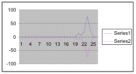
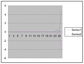
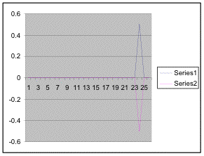
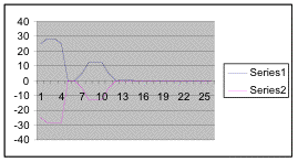
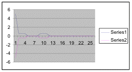
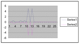
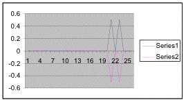
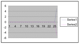
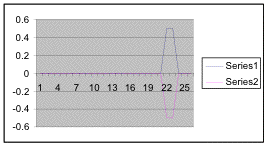
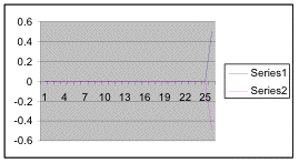
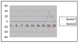
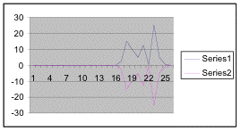
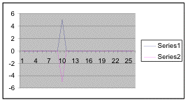
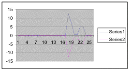
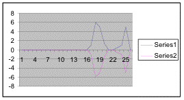
Kite Diagrams
BELT TRANSECT PROCEDURE
About 20 meters from the dock on the north side of Great Race Rocks, we plotted our transect. Starting at the shore and going 15 m inland, we laid a tape measure and at every half-meter we made a 50cm-by-50cm quadrant and counted the species in the plot.
ANALYSIS: We counted the algae by percent cover and the invertebrates by number. Some species overlapped, such as anthopleura and halosaccion. This coexistence was possible because the two species were not vying for the same food source. Species such as thatched barnacles and acorn barnacles did not live in the same quadrants, however. This may be because they are competing for the same substrate and nutrients and each prevents the other from invading into their space. As well, the thatched barnacles stopped growing at quadrant 15 but that is just where its competition, acorn barnacles began to grow. Perhaps one species was better suited to surviving farther up the shore.
That was the case for many of the species along the transect. Invertebrates like chiton, limpets and snails needed to be covered by the tide for most of its cycle. If these species tried to grow where they were exposed for a longer period of time, they would dry out and die. Other species like lichen need to be out of the water and as expected, were only found at high elevations on the transect.
The topography also affected the species diversity. The California Mussel, for example, was found only in quadrants that had crevices and rough substrate on which to grow.
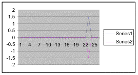
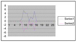
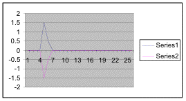
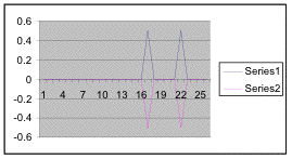
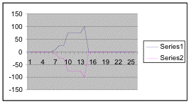
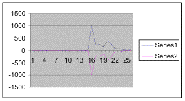
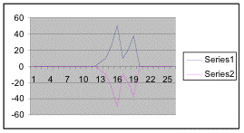
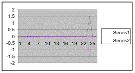
In general, the abiotic factor that had the greatest affect on species diversity on the transect was the elevation and amount of tide cover the area got during a tide cycle. Below are kite diagrams of each species we found on the transect.
Carmen and Jana Environmental Systems class April 2003
LINK to photographic transect strip of this area
This x-axis represents percentage cover for the macroalgaes. Note it may be a different scale in the graphs. The y-axis represents the .5meter quadrat location from the peg #15.
The “series” 1 and 2 just represent half of the value for each quadrat for the species, a way to get EXCEL to plot a symmetrical “kite” shape
Anthopleura elegantisima ( green intertidal anemone)
Hedophylum sp. ( Brown wrinkled algae)
Analepus sp. ( rare algae)
Praseola sp. (green mat algae)
Xanthorea sp. (yellow Lichen)
Porphyra.sp

Hildenbrandia sp. ( red thin cust algae)
Alaria marginata ( brown Algae)
Coralina sp. ( pink coraline algae)
Fucus sp.
Gigartina sp. (red algae)
Cryptosiphonia sp. (like wet dog hair)
Halosaccion sp.. (salt sac algae)
Golden Diatom
Ulva lactuca Sea lettuce
Mitylis californianus California mussel
Searlesia dira ( Spindle Whelk)
Amphysia sp. Snail
Neomolgis sp. Red Spider Mite
Purple Nucella Snail

Limpet
Acorn Barnacles
Thatched Barnacles
Littorina Periwinkle snail
Katharina sp. (leather chiton)
See Transect A0050101
See Transect A0050102
See Transect A0050103
![]()
Return to the Contents page for Environmental modelling with Transects..