Dobrocky Sea- Tech, Victoria
The Intertidal and Subtidal Macroflora and Macrofauna In the Proposed Juan De Fuca National Marine Park Near Victoria, B.C.
James M. Goddard, M.Sc. Dobrocky SEATECH Limited 130 Kingston Street Victoria, B.C. V8V lV4 383-5323
A Report to the National Parks Branch
Department of Indian Affairs and Northern Development. May 30, 1975
ii
Table of Contents
Table of Contents
List of Figures
List of Appendices
iIntroduction
1–Sites Investigated
4–Marine Environmental Factors in the Proposed Park Area
4–Description of the Marine Flora and Fauna
18–Aldridge Point
23–Southwest Islets
26–Edye Point
30–Bentinck Island
34–Swordfish Island34
35–Albert Head41
45–Race Rocks45
48–South Bedford Island48
51–Summary of Marine Flora and Fauna51
52–Comments on the Proposed Park
55–Shipwrecks and Other Artifacts
57–References
58–Appendices
iii
List of Appendices
| Appendix 1 | Terms of Reference | 58 |
| Appendix 2 | Species list – Aldridge Point | 61 |
| Appendix 3 | Species list – Southwest Islets | 64 |
| Appendix 4 | Species list – Edye Point | 67 |
| Appendix 5 | Species list – Bentinck Island | 70 |
| Appendix 6 | Species list – Swordfish Island | 73 |
| Appendix 7 | Species list – Albert Head | 76 |
| Appendix 8 | Species list – Race Rocks | 78 |
| Appendix 9 | Species list – South Bedford Island | 80 |
2-3
Click to enlarge
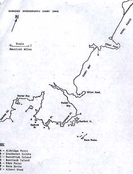
Figure 1: Map of proposed park area, showing sampling and photographic sites.
4
Sites Investigated
The sites investigated in this survey were selected as representative of the rocky shore extending from Albert Head to Beechy Head (Figure 1.). The Albert Head and Edye Point sites were selected as representatives of the relatively protected east-facing rocky shore, while the Bentinck Island situation was chosen to represent a partially-protected cove. Aldridge Point and the Southwest Islets were representatives of the outer portions of Becher Bay (Figure 1) . Both intertidal and subtidal transects were investigated at four of these stations. At Albert Head only the intertidal transect was carried out, as investigations at the other four sites (above) indicated a relatively uniform and predictable subtidal flora and fauna throughout most of the study area. Accordingly, further effort in the description of subtidal biota was directed to the unique areas within the proposed park The unique areas were Race Rocks, with the high-velocity currents; a submarine cave at Swordfish Island; and a sheer rock wall at South Bedford Island (Figure 1). All species identifications and field surveys were carried out by professional biologists. Species identifications were established using keys and the reference collections of Dobrocky SEATECH Limited, the University of Victoria and the B.C. Provincial Museum.
Environmental Factors in the Proposed Park Area
The oceanography of Juan de Fuca Strait has been investigated by Herlinveaux and Tully 1, who describe the strait as a complex, deep, positive estuary. During the flood tide deep ocean water
5
moves eastward along the bottom of the strait and, in the vicinity of the San Juan Islands, mixes with the brackish waters flowing seawards from Georgia Strait. Part of the mixed water returns to the Georgia Strait system, and part escapes seaward as the near surface water of Juan de Fuca Strait 1. Thus, the surface waters in the proposed park area are a mixture of warm, brackish Georgia Strait water (including some freshwater from the Fraser and smaller rivers) and cold, saline ocean water, relatively rich in nutrients.
The surface water temperature and salinity data from Race Rocks for the decade 1948 to 1957 were compiled by Stephenson and Stephenson 2. These results are summarized in Figure 2a. Mean salinity values were near 31 /oo throughout the year. Herlinveaux and Tully1 noted that surface salinity maxima occurred in March and October, with minima in January and in mid-summer (June-July). The horizontal distribution of summer and winter surface salinity values in Juan de Fuca Strait is summarized in Figure 2b. Mean surface water temperatures for the decade 1948 to 1957 were 6 to 7 C in January, rising to 10 to 11 C in August and September (Figure 2a). The horizontal distribution of summer and winter surface temperature values is summarized in Figure 2c.
These values for temperature and salinity are largely in agreement with similar data obtained over a two year period near Victoria harbour 3 and during a limited survey off William Head 4 Thus, there appears to be no obvious horizontal gradient of temperature or salinity that should affect the horizontal distribution of marine organisms within the proposed park area.
6
Figure 2: Temperature and salinity data for Race Rocks and Juan de Fuca Strait.
7
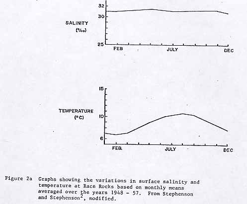
showing the variations in surface salinity and temperature at Race Rocks based on monthly means averaged over the years 1948 57. >From Stephenson and Stephenson2, modified.
8
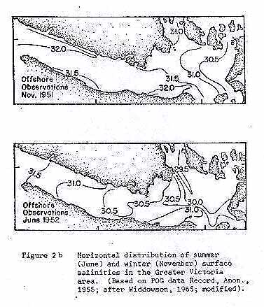
Figure 2b: Horizontal distribution of summer (June) and winter (November) surface salinities in the Greater Victoria area. (Based on POG Data Record, Anon., 1955; after Widdowson, 1965; modified)
9
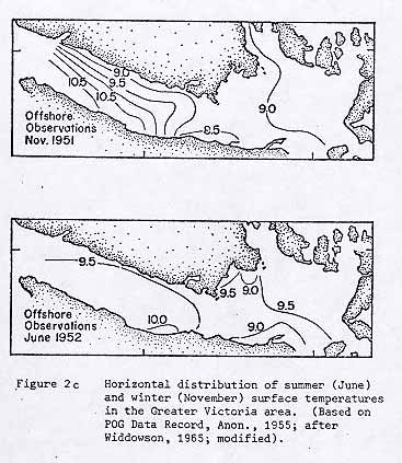
Figure 2c: Horizontal distribution of summer (June) and winter (November) surface temperatures in the Greater Victoria area. (Based on POG Data Record, Anon., 1955; after Widdowson, 1965; modified).
10
Surface oxygen contents in the area of the proposed park are generally in the range 6 to 8 mg/l 1,3, and never fall to levels that might affect the horizontal distribution of the marine organisms.
Water clarity in Juan de Fuca Strait is a seasonally dependent phenomenon, being largely determined by the phytoplankton content of the water. Thus, in the winter low phytoplankton populations result in clear water, except in the aftermath of storms. In summer, on the other hand, underwater visibility is greatly reduced as the phytoplankton population increases. There are no large streams or rivers near the proposed park site, so there is no significant turbidity due to freshwater run-off.
The tides in the area of the proposed marine park are of the mixed,mainlydiurnal type (Figure 3). According to the introduction to the Canadian Tide and Current Tables, there are usually two complete tidal oscillations daily. The inequalitie*s in the heights of successive high or low waters and the corresponding time intervals are very marked5. The mean tidal range is 5.7 feet at Victoria, and 6. 1 feet at Sooke (Figure 3) while during large tides, the ranges may reach 9.3 feet and 9.9 feet respectively. The lower low tides occur in the daylight hours during spring and summer (March to August), and during the night in the fall and winter.
The different times of day at which the low water of spring tides occur throughout the year have a considerable influence upon conditions in the lower levels of the shore. Along the coast of British Columbia the low water of spring tides
11
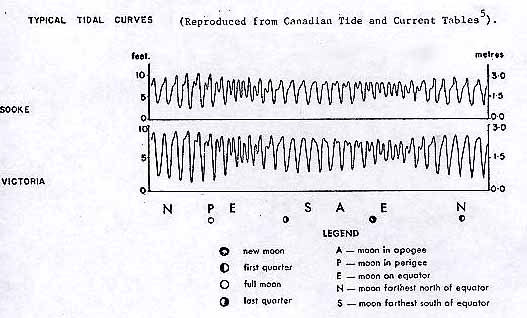
Figure 3: Typical tidal patterns at Sooke and Victoria.
12
Typical Tidal Curves (Reproduced from Canadian Tide and Current Tables).
13
occurs at night during the fall and winter, exposing the intertidal organisms to the minimum air temperatures and risk of ground frost. Conversely, the summertime (March to August) low waters of spring tides occur during daylight hours, exposing the intertidal organisms to strong and direct sunlight. Such exposure leads to rapid heating of the substrate and organisms, and to a correspondingly high rate of evaporation. Shaded situations such as crevices and north-facing surfaces would be subject to lower temperatures and a lower rate of evaporation than adjacent sun-lit rock faces.
Currents in the study area range from weak to strong, depending upon the specific locality under consideration. The greatest velocities occur around Race Rocks, and through Eemdyk Passage, with values ranging from 2 to 7 knots. Similar velocities also occur around the promontories to the west of Race Rocks: these are Beechy Head, Aldridge Point, the Bedford Islands, Church Point and Christopher Point (Figure 4). Moderate current velocities (1 to 2 knots) occur in the outer parts of Becher Bay and Pedder Bay; similar velocities may also occur off William Head and Albert Head (Figure 4). Parry Bay and Royal Roads are subject to weak currents only, with velocities usually less than 1 knot.
Currents are of relatively minor importance in influencing the local distribution of intertidal organisms. It matters little whether the currents be strong or weak so long as food and nutrients are supplied, and reproductive stages are dispersed to colonize or replenish distant as well as nearby areas. In subtidal situations, however, the magnitude of the current does have a marked influence upon the biotic communities. Certain species assemblages are
14 – 15
Figure 4: Distribution of currents in the proposed park area
16
found only where high-velocity currents occur, whereas other forms are characteristic of quiet, sheltered waters. Many of the areas investigated in this project show the species characteristic of moderate to high-velocity areas.
The proposed marine park shore is periodically subject to strong wave action during the southeasterly or southwesterly gales characteristic of the fall and winter months. A prolonged westerly storm may produce swells 10 to 15 feet high, with 3 to 6 foot high wind waves superimposed. Southeasterly gales produce smaller swells (8 to 12 feet high) because of the limited fetch available across the Straits of Juan de Fuca. The calm periods between gales and in the summer are usually a time of no wave action along the coast north of Race Rocks or, to the west of Race Rocks, a surge produced by the low westerly swells (3 – 4 feet high) that are present throughout most of the year.
All shores, except the most protected embayments, occasionally experience storms when waves and spray reach to very high levels. This unusual wetting of higher shore areas can have no permanent effect upon the vertical distribution of shore organisms 6. However, where waves and swells are constantly experienced, their regularity and amplitude must obviously raise the effective wetting level of the sea above the level indicated by the height of the tide6. Thus, on rocky shores exposed to constant wave action, the recognizable biological zones are wider (vertically) and extend further up the shore than on shores protected from such regular wave action. This contrast may be noted between the wave
17
exposed coast west of Race Rocks, which is subject to almost continuous low westerly swells, and the relatively sheltered coast north of Race Rocks (Figure 1) which experiences pronounced wave action only during southeasterly gales in fall and winter. Lewis considers wave action as the single most important factor determining the composition of shore populations and their distribution. In general, as the frequency and strength of wave action increases, the number of species present becomes reduced. This effect is not obvious in the proposed park area as the usual wave action on the shore west of Race Rocks is a smooth surge, rather than a violent surf.
The rocky shores throughout the proposed park area are generally smooth, steeply sloping and dissected by numerous cracks and crevices. The topography and substratum of a shore influences the gradient of conditions on the shore by variations in the water-retaining capacity. As the tide recedes, the intertidal areas start to dry out. The rate of drying depends, firstly, upon the slope of the shore, with steeply sloping rock faces draining more rapidly than undulating platforms or shallow slopes. Cracks and crevices provide micro-environments in which the rate of drainage, and the drying effects of sun and wind are greatly reduced, and permit colonization to higher levels on the shore than occurs on the open rock faces in the same location. This “uplift” of the intertidal zonation may be noted in cracks and crevices throughout the proposed park area.
The vertical distribution of subtidal organisms is largely dependent upon illumination. Most of the green and brown algae are restricted to situations within 15 feet of the lowest tide level, whereas certain red algae may be found down to 50 feet depth. Animals which graze upon the green and brown algae only will thus be found only near the surface. The deeper-living species of invertebrates are primarily filter-feeders, predators or scavengers, rather than grazers.
18
Description of the Marine Flora and Fauna in the Proposed Park Area
Aldridge Point in Becher Bay (see Figure 5 and Appendix 2)
Aldridge Point (Figure 1) is a rocky outcrop with a small cove on the north side. The cove has a gravel beach and is bounded by the terrestial vegetation, comprised of arbutus, Douglas fir, salal and pine. The rocky area is composed of bedrock with many smooth vertical faces, dissected by numerous cracks and crevices. There are also large boulders piled one on top of the other down to the low tide level. Many of these boulders are up to 4 feet in diameter. A detailed species list for this area is presented in Appendix 2. In summary, the intertidal area shows the species that are characteristic of moderately waveexposed areas of southern Vancouver Island. The flat rock faces of the upper intertidal are sparsely populated by barnacles, lichens and algae (Porphyra and Fucus distichus).The numerous cracks and crevices harbour snails’, crabs and limpets, while tidepools are inhabited by anemones, mussels, limpets, snails, hermit crabs and coralline algae.
The mid-intertidal region supports a richer flora than occurs in the upper intertidal (Appendix 2). A total of seven species of macroflora are present-, with all three major groups (red, brown and green algae) represented. Tide pool flora and fauna
19
Figure 5: Schematic profile – Aldridge Point.
20
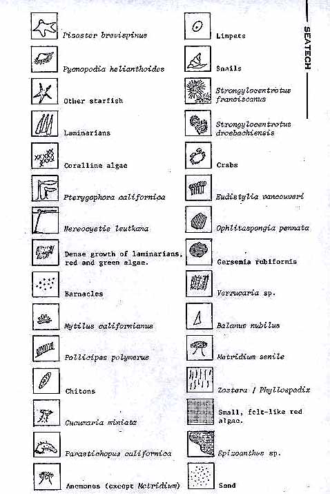
Vertical profile and species key (two illustrations)
21
in this region are similar to those which occur at higher levels on the shore. Starfish are found in this region, but tend to remain in damp crevices or hollows. The snails, crabs and limpets noted in the upper intertidal are also to be found here in the mid-intertidal.
The low intertidal area supports a great diversity of species. Most orders of macrofauna are represented by two or more species: for example, starfish (4 species), chitons (2 species), limpets (3 species). Similarly, the coralline algae and the kelps (large brown algae) are each represented by two or more species, and are more numerous than at the higher levels on the shore (Appendix 2). This site shows, on a small scale, some of the variation in species distribution between relatively sheltered and relatively wave-exposed situations. For example, the mussel Mytilus californianus is found on the tip of Aldridge Point, but not on the rocks bordering the sheltered cove. Similarly, the gooseneck barnacle, Pollicipes polymerus occurs on the most wavebeaten rocks at Aldridge Point and is absent from the relatively protected situations.
Below low tide level the substrate is a gently sloping sand flat which extends offshore for some distance before a water depth of 40 feet is attained. In the shallow water (down to approximately 30 feet depth) the sand supports an eelgrass meadow which, in turn, provides a substrate for the anemone Epiactis prolifera. A litter of empty clam shells, principally Saxidomus sp., on the sand attests to the presence of a clam population in the area. This is confirmed by observations of the large starfish
22
Pycnopodia helianthoides and Pisaster brevispinus digging for, and feeding upon the clams. Rock outcrops in the shallow subtidal area (down to 20 feet depth) support a Pterygophora forest and characteristic associated flora and fauna (Appendix 2). A large Anemone, Taelia sp.) adheres to the rock, whereas the smaller Epiactis prolifera grows on the Pterygophora stalks. Two species of holothurian are to be found: the sessile, bright orange Cucumaria miniata lies buried in the sand at the base of cliffs and boulders, while the motile Parastichopus californica, a detritus feeder, browses over the rock surface. The green sea urchin (Strongylocentrotus droebachiensis) grazes upon small red and brown algae on the rocks, and upon pieces of decaying kelp lying on the bottom. Aggregates of 15 to 20 individuals sitting closely packed upon a piece of kelp are not uncommon. In slightly deeper water (20 to 30 feet depth) the green urchin becomes less common and is replaced by a larger form, the red Strongylocentrotus franciscanus. Also at this depth the green and brown algae reach the deep limit of their distribution, and the flora Is represented primarily by red algae. The giant kelp Nereocystis sp. has its holdfasts attached to the rock at this depth, although its fronds float at the sea surface.
Throughout the subtidal area investigated, chitons and limpets are found grazing on the rocks, while kelp crabs and edible crabs (Cancer productus) live in the Pterygophora forest and on the sand flats respectively. A detailed list of the species noted is presented in Appendix 2.
23
Southwest Islets in Becher Bay (Figure 6 and Appendix 3)
The Southwest Islets are a small rocky group on the southwest side of Frazer Island in Becher Bay (Figure 1). The larger of these islands is connected to Frazer Island by a sand spit which is exposed at low tides. This sand substrate continues into the subtidal region and supports an eelgrass meadow. Specimens of the butter clam Saxidomus sp.and the littleneck clam Protothaca staminea are found in thesand. Specimens of the large starfish Pisaster brevispinus (which feeds upon clams) were seen in the shallow subtidal region. Intertidal tidepools amongst the rock outcrops contain many of the larger intertidal animals such as the holothurians Cucamaria miniata and Parastichopus californica, hermit crabs, shore crabs(Hemigrapsus nudus), littorine snails and small fishes. The rock faces are similar to those described for Aldridge Point: namely, large flat relatively steeply sloping areas dissected by crevices and small gullies. The upper intertidal supports a population of Fucus and barnacles. The macroflora and macrofauna of the mid and lower intertidal areas are very similar to those described above for the exposed tip of Aldridge Point. The species represented here are those normally found on southwestern shores of Vancouver Island in areas subjected to moderate wave action. For example, the gooseneck barnacles Pollicipes polymerus are present, together with the large mussel Mytilus californianus. Rock fractures and small gullies in the mid intertidal provide damp situations where anemones and starfish are found. Throughout the mid and lower intertidal regions, chitons (3 species) , limpets (4 species) and snails (4 species) are present.
The algal population is similar to that noted at Aldridge Point,
24
Figgre 6: Schematic profile – Southwest Islets.
25
Two figures here: species key and profile
26
with the greatest numbers of species and of individual plants occur ring in the lower intertidal region (see Appendix 3 and Figure 6).
The subtidal community is very similar to that described at Aldridge Point. The substrate is a shallow, gently sloping sand with boulders and rock outcrops. The sand areas are populated by clams which apparently provide part of the diet for the large starfish Pycnopodia and Pisaster brevispinus. Eelgrass occurs in some situations but is not very well established everywhere. This is probably a consequence of considerable wave action during storms. The rock outcrops support a Pterygophora forest with all the subsidiary flora and fauna as described previously (page18) for Aldridge Point. (See also Appendix 3 and Figure 6). Edye Point (Figure 7 and Appendix 4)
The intertidal region of Edye Point is a series of low rock outcrops, separated by cobble and gravel beaches, and becoming near-flat rock platforms in the low intertidal region. These beaches are bare of all life down to the low intertidal where they give way to almost horizontal rock platforms. The rock surfaces in mid and upper intertidal areas are inhabited by the barnacle Balanus cariosus, 2 species of limpets and the alga, Fucus. Some very small tide pools are found in the mid-intertidal area and these support most of the species that occur in similar situations at Aldridge Point and the Southwest Islets. The small anemone Anthopleura elangantissima is very numerous, as is the pink coralline alga, Bossiella. Several species of snails and a few specimens
27
Figure 7: Schematic profile – Edye Point.
28
two diagrams here: one species key and the other a profile
29
of mussels, hermit crabs and chitons are found in these pools also. The flora and fauna of the rock platforms in the lower intertidal are similar to those found at Aldridge Point and the Southwest Islets. Like those situations, Edye Point is occasionally subject to moderate wave action. Specimens of the kelp,Pterygophora and the California mussel(Mytilus californianus) are present in this area. Anemones arerepresented by Taelia crassicornica and the small anemoneAnthopleura elegantissima. Starfish are also found here, represented primarily by Pisaster ochraceus, Pisaster brevispinus, Henricia leviuscula and Solaster stimpsonii. Some barnacles are found in these low intertidal areas but they are relatively few and far between, whereas limpets, snails and cbitons are very numerous. The large algae are represented by approximately 8 species, ranging from the small green alga(Ulva or Monostroma) to the large kelps and laminarians. Some specimens of the surf grass Phyllospadix are found in sandy pockets in the rock plateaux. A detailed species list for this area is presented in Appendix 4.Below the low tide level the bottom is a gently sloping broken rock area. Down to a depth of 10 feet this broken rock is totally covered with a low red alga, Rhodoptilum sp.At a depth of 15 feet the Pterygophora forest begins, accompanied by the subsidiary flora and fauna described for Aldridge Point (see also Appendix 4). With increasing distance offshore, the rock areas become increasingly separated by patches of sand, until, at 50 to 75 yards from the beach, the bottom is a sand flat interrupted by occasional low rock outcrops (Figure 7). The sandy area is
30
inhabited by crabs (Cancer productus), clams and the starfish Pycnopodia and Pisaster brevispinus.At the time of this survey no eelgrass was present. At depths down to 25 feet the rock outcrops are populated by the Pterygophora forest community. The giant kelp Nereocystis is anchored to these rocks although its fronds float at the water’s surface. In general, the subtidal situation at Edye Point is very similar to that at Aldridge Point, described on page18. A detailed species list is presented in Appendix 4 and represented diagrammatically in Figure 7.
Bentinck Island (Figure 8 and Appendix 5)
The study site on Bentinck Island is a small cove facing to the southwest onto Juan de Fuca Strait (Figure 1). A relatively steep cobble and gravel beach slopes down from the terrestial vegetation to the water. The beach is interrupted by rock outcroppings and is bordered at either side of the cove by rocky points. The following discription refers to these rocky points. The upper intertidal area is inhabited by littorine snails, barnacles and 4 species of limpets. Tide pools support 4 species of anemone, the mussel Mytilus californianusand 3 species of chitons. Some chitons are also found on the dry rock faces. The algae at this level on the shore are represented by Fucus, Gigartina, Enteromorpha ,Endocladia and Porphyra. The mid-intertidal is mostly composed of steeply sloping rock faces with many cracks, crevices and ledges or is made up of a plateau with small boulders. In this region the purple sea urchin Strongylocentrotus purpuratus is occasionally found beneath boulders, together with specimens of the green urchin
31
Figure 8: Schematic profile – Bentinck Island.
32
two figures here: one the species key and the other a profile
33
Strongylocentrotus droebachiensis. Several anemones such as Anthopleura and Taelia are resident here, either in tide pools or hiding under rocks in damp situations. The tube worm Eudistylia vancouveri may be present wherever there is a small deposit of sediment in some cracks in the rock. Chitons are represented by 4 species. The starfish Pycnopodia, Pisaster and Henricia are found at this level on the shore although usually only in damp situations. The algae are represented by a mixture of the greens, browns and the red algae, and are detailed in Appendix 5.
In summary, the mid-intertidal area is primarily characterized by the fauna and the flora are numerically subordinate. This situation is reversed in the low intertidal area especially on flat rock platforms. Here the algae are the predominant life form. In some cases the algal cover is so complete that the larger fauna are excluded. There are approximately 30 species of algae as detailed in Appendix 5. The macrofauna are represented by the occasional specimen of starfish Pisaster or Henricia and isolated specimens of the limpet, Acmaea scutum. On vertical surfaces where the algal cover is less complete, bright red patches of a low encrusting sponge (Ophlitaspongia pennata) are found.
The subtidal area in this cove on Bentinck Island is composed of a gently sloping sand bottom with occasional boulders and rock outcroppings. The sand supports an eelgrass meadow (Zostera marina) which in turn provides a substrate for small snails (Lacuna sp. or Littorina sp.). No anemones (Epiactis prolifera) were present on the eelgrass during this survey. The boulders and rock outcrops in the bay support a sparse Pterygophora
34
forest community. Subordinate flora in the Pterygophora forest include Iridea, Plocamium and Cladophoraand some smaller algae (detailed in Appendix 5) as found in similar shallow subtidal situations throughout the study area. The depth of water is not very great, being less than 15 feet throughout the bay and in Eemdyk Passage Figure 1).
Swordfish Island (Appendix 6 and Figures 9 and 10)
No intertidal observations were carried out at this location. The feature of interest here is a submarine cave which runs through the full width of Swordfish Island (Figure 9). This cave is triangular in section, the apex lying approximately 4 feet above lowest low tide. The bottom is approximately 8 feet below lowest tide level and 6 to 8 feet in width. Several species of animals which normally occur only subtidally are found intertidally within the cave. An example of this is the bright orange soft coral Gersemia sp. Which usually occurs in deep water (depths in excess of 30 feet) in areas of high current velocity. Below the lowest water level the walls of
the cave are densely covered by the large white anemone, Metridium senile. A detailed species list of the flora and fauna occurring in this cave is presented in Appendix 6.
35
Figure 9: Schematic profile – Submarine cave in Swordfish Island.
36
Two figures here: one a species key and the other the profile.
37
A survey of the subtidal flora and fauna on the outside of the island adjacent to the cave was carried out as a contrast and supplement to observations in the cave. The north side of the island forms a boundary of a small cove with a relatively shallow sand bottom. The other side of this cove is formed by the main part of Vancouver Island as shown in Figure 1. This shallow sand bottom is covered by an eelgrass meadow which in turn provides a substrate for the anemone Epiactis prolifera. The rock of Swordfish Island slopes steeply into the water at an angle of approximately 55-60 degrees and adjacent to the mouth of the cave, meets the sand at a depth of 15 feet. On this steeply sloping rock face the Pterygophora forest is again well established. Pink coralline algae provide a considerable low coverage on the rock in the shallow subtidal areas but are absent at depths greater than 8 to 10 feet. Occasional specimens of kelp crabs, hermit crabs and the green sea urchin, Strongy1ocentrotus droebachiensis occur amongst these algae. In slightly deeper water as the coralline algae thin out, the solitary coral Balanophyllia elegans appears. Chitons, holothurians, limpets and starfish are all represented, as detailed in Appendix 6. A few specimens of the crab Cryptolithoides were also noted. On the south side of the island the coast is open to the swell from Juan de Fuca Strait. The rock substrate of the island again lies at a relatively steep angle. However, this does not level off until a depth of about 75 feet is attained (Figure 10). Down to a depth of 15 feet the species present correspond with those described above for the protected northern side of the island. Below 15 feet depth, the algal cover drops off rapidly leaving the
38
Figure 10: Schematic profile – Swordfish Island.
39
Two diagrams: one the species key and the other a profile.
40
the rocks relatively barren, except for patches of hydroids and small red algae. At depths of 25 feet or greater the predominant macrofaunal species is the large red urchin Strongylocentrotus franciscanus although a few specimens of Strongylocentrotus purpuratus may also be found. The cracks between the boulders provide a home for large numbers of ophuroids. The chiton, Tonicela lineata is still present at these depths, together with the nudibranchs Archidorismontereyensi (yellow) and Archidoris odbneri (white). At depths of approximately 40 feet small snails, Bittium sp. and Calliastoma ligatum are found in small crevices and cracks in the rock. At these depths the starfishes are represented by Pycnopodia helianthoides, Solaster stirpsonii,Evasterias, Dermasteriasand Henreciaeviuscula..
The rock cliff on the Vancouver Island side of the cove extends down to a maximum depth of 50 feet before it meets with the sand bottom of the cove. Throughout the full vertical range of this cliff, large numbers of the white anemone, Metridiumenileare found. Rock ledges nearest to the surface support a Pterygophora forest with large numbers of the green sea urchin Strongylocentrotus drobachiensisand the boot chiton (Cryptochiton) present. Specimens of starfish (Pyonopodia sp.) and the large red urchin Strongylocentrotus franciscanusare also found. At greater depths on flat surfaces the large snail Fusitriton oregonensisand the starfishes Henrecia, Solaster and Midiasterare present. The holothurians Parastichopussp.browse along these ledges also. A detailed species list for this area is presented as Appendix 6 and a diagrammatic profile is presented as Figure 10.
41
Witties Lagoon near Albert Head (Appendix 7 and Figure 11)
This site is on the south side of Albert Head which forms the northern extremity of a sand beach along Parry Bay (Figure 1). The beach forms an extensive intertidal sandflat in the vicinity of Whitties Lagoon (also known as Metchosin Lagoon). This area supports a population of clams, representedbyClinocardium nuttallii, Saxidomus giganteus andProtothaca staminea. This appears to be an important feeding area for gulls who follow the receding tide line, apparently digging in the sand. The following description refers to the rock shore on the south side of Albert Head. The upper intertidal is populated by barnacles and littorine snails and a sparse population of algae (Fucus and Porphyra). Tide pools and crannies at this level support numerous specimens of small mussels (Mytilus edulis or small specimens ofMytilus californianus), snails and isopods. In the mid-intertidal area barnacles and Fucus are much more numerous, together with specimens of limpets, primarily Acmaea digitalis. Chitons(Katharina tunicata), snails (Nucella sp) and Pagurid hermit crabs are found in the damp crevices and tide pools. The anemone Anthopleura elagantissima isalso found here. In the lower intertidal area barnacles are extremely numerous and crowded, assuming the tall columnar shape characteristic of very crowded conditions. A green sponge (Halichondria)is also found here mixed amongst a bright red encrusting sponge (Ophlitaspongia pennata). Right at the bottom of the intertidal area coralline algae (Lithophyllum sp. and Bossiella sp.) become numerous. In small crevices where sediment accumulates the fan worm Eudistylia
42
Figure 11: Schematic profile – Albert Head.
43
Insert two diagrams: one with species key and the other with profile.
44
may be found. Similar cracks also support specimens of snails (Nucellapp.). Numerous juvenile specimens of the six-rayed starfish Leptasterias hexactis are found tucked away into little cracks and crevices, often in company with the shore crab Hemigrapsus nudus and occasional specimens of Katharina tunicata. The limpets are somewhat restricted in this situation by an absence of open rock face. The area is so heavily populated with barnacles that there is little room for the limpets.
A large crack into the rock face at this point provides a demonstration of the uplift of intertidal zones which occurs in such situations. In this area damp conditions prevail much further up the shore then on the open areas, and the fan worm Eudistylia becomes much more numerous. At the lowest level on the shore the coralline algae form a very heavy mat below which the laminarians are sparsely represented. At this level, the barnacles reach the lower limit of their distribution and the limpets (mostly Acmaea scutum) become numerous again. The subtidal situation is primarily a sand bottom which supports a Zostera meadow. The predominant factor about this area is the relative scarsity of laminarians. The algae in the shallow subtidal level are represented primarily by a filamentous red species similar to the situation described for Edye Point (page26). This area is not exposed to any significant wave action except during the southeast gales characteristic of the fall and winter months. A detailed species list is presented in Appendix 7 and a diagrammatic profile is presented in Figure 11.
45
Race Rocks (Figure12 and Appendix 8)
No intertidal sampling was carried out at Race Rocks. As this area is similar in location and wave exposure to Aldridge Point and the Southwest Islets a similar intertidal flora and fauna is expected. The unique feature at Race Rocks is the subtidal flora and fauna inhabiting the high current velocity channels. This survey was therefore confined to the subtidal areas.
In the shallow subtidal (to 20 feet depth) there is a Pterygophora forest with Laminaria sp. and the giant kelp Nereocystis leutkana. The associated fauna differ from those found in areas of lower current velocity (see, for example, Aldridge Point). Extensive mats of the pink coralline alga Corallina are overgrown by numerous small anemones, Epiactis prolifera which occur here in far greater density and colour variation than elsewhere in the proposed park area (see plate 1). This anemone is usually green. At Race Rocks, however, it is found in pink, orange, red and blue colours. Exposed rocks are covered with the pink or blue hydrocoral Allopora sp. (plate 2) and specimens of the solitary coral Balanophyllia elegans. Amongst boulders or in gullies, the sea urchins Strongylocentrotus droebachiensis and Strongylocentrotus fransciscanus, and the starfish (such as Solaster dawsoni) are found. Extensive populations of the large mussel Mytilus californianus are also found in the shallow subtidal area, at times achieving 100% coverage of the substrate over large areas. Smooth rock areas in back eddies support large numbers of abalone. This is the only sampling site which showed a population of abalone, all others having been subject to recent commercial exploitation.
46
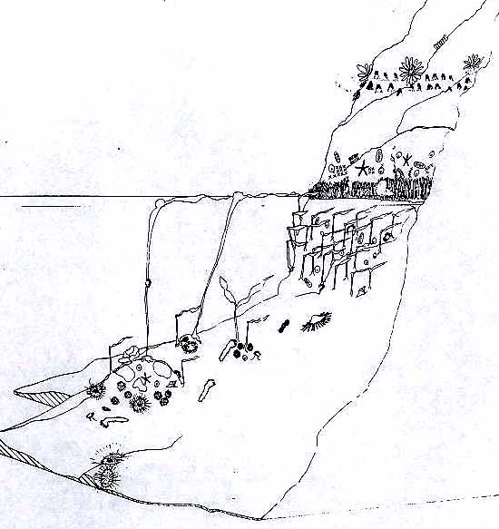
Figure 12: Schematic profile and key- Race Rocks.
 47.48
47.48
At greater depths (30 to 50 feet) the macro-algae are greatly reduced, and are represented only by the pink encrusting Lithophyllum sp.and occasional specimens of Lamnaria. Feather-like hydroid colonies are found on the rocks and give the appearance of small algae. The giant barnacleBalanus nubilus is found at these depths, as is the soft coralGercemia rubiformis and the large ophiuroid Gorgonocephalus eucnemis (plate 2). Anemones are represented by four species, with the white Metridium senile the most numerous of these.The red sea urchin Strongylocentrotus franciscanuss is well represented at this depth, while only occasional specimens of the green and purple urchins (S. droebachiensis and S.purpuratus) are found. Three species of starfish were found at this depth during this survey, and these differed from the three species found in the shallower water (see Appendix 8). There is no reason to regard this as a depth preference rather than normal sampling variation. The less frequently encountered fauna include nudibranchs, snails, crabs, rock scallops and sponges (Appendix 8).
South Bedford Island (Appendix 9)
No intertidal sampling was carried out at South Bedford Island, as the interesting feature here is the subtidal cliff, and the wreck of the “Swordfish” (see page 55). The shallow subtidal area is dominated by aPtepygophora forest, with a dense (Corallina or Bossielila sp.). The red algae Iridea sp. and Desmarestia sp. occur in isolated patches separated by the coralline algae. Any rock surfaces
49
Plate 1 -Epiactis prolifera at Race Rocks.
Plate 2 – Showing Metridium senile, Allopora sp., Epiactis prolifera, Gersemia rubriformis,, Gorgonocephalus eucnemis and Strongylocentrotus franciscanus.
50
found to be bare of algae are densely populated by three or four species of snails. The solitary coral (Balanophyllia elegans) was common, and the pink hydrocoral Alloporasp. (which also occurs intertidally here) is found under steel plates of the wreck or
in crevices. Starfish (Asteroidea) were represented by three of the most common species found in the proposed park area, namely Pycnopodiasp., Solaster sp., and Henricia sp. (Appendix 9). The green urchin (S. droebachiensis was present in shallow water (down to 20 feet depth) and the red urchin (S. franciscanus) became common at greater depths (30 to 40 feet). Crabs were represented by numerous large Pagurid hermit crabs (unidentified), occasional specimens of Cryptolithoides sp ,and one large box-crab (Lopholithoides sp.). Anemones were represented only by isolated groups ofEpiactis prolifera. Chitons were commonpredominantly Cryptochiton stelleri, with Tonicella lineata and occasional specimens of Mopalia sp.
The situation described above exists across a shallow reef, and down the gently sloping sides of the reef to a depth of 30 to 40 feet. Beyond that depth the substrate becomes a sheer rock wall down to 90 feet depth at one side of the reef and down to 250-300 feet on the opposite side. This rock wall is almost totally covered with the large (up to 3 feet high) white anemone,Metridim senile.
A detailed species list for this area is presented in Appendix 9.
51
Summary of Marine Flora and Fauna in the Sites Investigated
The intertidal species of macroflora and macrofauna noted during this survey are listed in Appendices 2 through 5. In summary, all sites showed some or all of the macroflora and invertebrate fauna characteristic of the southwest coast of Vancouver Island. This is an area of steeply sloping rock shores, bordering a cold, saline water mass which shows little seasonal fluctuation in any of the physical environmental parameters. The intertidal flora and fauna are diverse and abundant in most situations, becoming somewhat less diverse, but no less abundant in areas subject to continuous heavy wave action. The subtidal flora and fauna are constant and uniform. (Appendices 2 through 7) at the sites subject to moderate to weak currents. In areas of high-velocity currents (primarily Race Rocks) a unique biotic community is found (Appendix 8). The unusual feature is not only the appearance of species not found elsewhere (Gersemia sp., Gorgonocephalus sp., etc.), but also the unusual abundance of some ubiquitous species (Corallina sp. and Epiactis prolifera).
52
Comments on the Proposed Park
In reading this report, a person who is not familiar with the marine biology of southern Vancouver Island will overlook the significance of the data presented here in support of the proposed marine park. Westwards from Race Rocks, one finds the marine flora and fauna of the partially exposed southwest coast of Vancouver Island, gradually merging with the species of the exposed (to heavy wave action) west coast of the Island. Thus, the flora and fauna of the William Head – Race Rocks – Beechey Head shoreline is not typical of conditions closer to Victoria and in Georgia Strait, but is still within a short distance of Victoria. The high current velocities around Race Rocks and towards Beechy Head tend to concentrate organisms to higher population densities than occur elsewhere. Thus some species, usually rare, may be found in this area in surprising numbers. The proposed park therefore encompasses an area which supports an unusual flora and fauna, of surprising beauty even to the non-biologist.
If the proposed park becomes a reality there should be an increase in the number of persons visiting the area. Since the majority of these persons will probably have had little or no previous contact with this area, some warning, of the potential dangers is required. Most of the shoreline from William Head to Beechey Head is presently accessible only by boat. This shore is
53
pedominantly steeply sloping rock and is usually washed by a 2 to 4 foot westerly ground swell. Under these conditions boat landings are potentially hazardous and should be attempted only by experienced operators. It should be pointed out to visitors that this area is generally not suitable for family picnics and similar activities.
The strong currents in this area (William Head to Beechey Head) represent a hazard to divers. However, the most potentially dangerous areas support the most interesting and beautiful underwater life, as documented by the photographs and the motion picture accompanying this report. Since the majority of the divers who might be expected to visit the park will be inexperienced in diving in high current areas I strongly recommend that a guide-diver service be implemented. The guides should be excellent divers and be very experienced at small boat operations. Each guide must be given absolute authority, similar to that of the master of a vessel, over the party in his care, since their safety will depend upon his guidance. This would enable visiting divers to be conducted in relative safety to the most interesting underwater areas of the park. In contrast to this the shore north of William Head is mainly a sandy beach and is not exposed to rough water or strong tides. This area thus offers no unusual hazards to boat operation and diving and is an excellent area for family picnics.
The problem of bringing the non-diving public into contact with the underwater beauty of the marine park is likely to occupy the attention of the park planners for some time.
54
Underwater visibility in this area is usually less than 30 feet, so that visitors to an underwater gallery would view only the small area in the immediate vicinity of the building. A more versatile approach would be a large aquarium system, similar in concept (though not necessarily in size) to the Vancouver aquarium. This should be established under the direction of an experienced marine biologist/ecologist to reproduce on a small scale some of the species associations (and the necessary ecological condition) found in the proposed park area. This exhibit could also be supplemented with lectures, underwater photographs and cine films which would be of interest and benefit to all sections of the community.
55
Shipwrecks and Other Interesting Artifacts Within the Proposed Park
The coastline encompassed by the proposed park boundaries has a history of maritime disasters brought about by the strong currents and stormy winter weather, compounded in the early days of maritime commerce by the absence of aids to navigation. The reefs of the Race Rocks group have claimed numerous vessels, but to our knowledge, the wrecks of none of these have been located. However, there has been little serious exploration of the reefs because of the strong currents encountered. Royal Roads, off the entrance to Esquimalt and Victoria harbours, provides a safe anchorage for vessels except during easterly or southeasterly storms. Vessels caught here at anchor by unusually violent southeasters stand the risk of being driven ashore. In the past many sailing vessels have been stranded on the rocks of Albert Head or on the adjacent beaches. All these vessels were refloated or dismantled, so no known wrecks remain in this area.Two shipwrecks are known within the proposed park area. The wreck of the steamer “Barnard Castle” lies in a bay on the east side Bentinck Island, and the sailing ship “Swordfish” lies just off South Bedford Island (Figure 1). The remains of the “Barnard Castle” were dynamited in salvage attempts and further broken by storm waves, reducing the wreck to a litter of steel plates, amongst which is a large boiler and a steel propellor. The wreck
56
lies in the middle of the bay (Figure 1) with the bow towards shore, in water ranging from 15 to 35 feet in depth. Although there are very strong currents past the entrance to the bay the major portion of the wreck lies in calm water. Unusually large, black rockfish (Sebastodes melanops) usually school above the wreck, and octopus are often seen beneath the steel plates. (The author has not visited this wreck, and is grateful to Mr. Frank White, Jr., of Victoria for supplying the foregoing information).
The “Swordfish” was a steel-hulled sailing vessel which struck South Bedford Island and sank on the spot. The wreck is broken into two portions; a shallow portion, which lies across the reef, from 10 feet depth down to 40 feet, and a deeper portion at a depth in excess of 100 feet. The shallow portion of the wreck has been dismantled, probably by wave action. The debris of large steel plates and three steel masts lies across the reef. There is also an anchor, presumably from this vessel, in shallow water on top of the reef. This area is subject to considerable wave action and high current velocities, and is accessible to divers only during calm weather and at slack water.
57
References
1 Herlinveaux, R.H. and J.P. Tully (1961). “Some Oceanographic Features of Juan de Fuca Strait.” J. Fish. Res. Bd. Canada, 18 (6):1027-1071.
2. Stephenson, T.A. and A. Stephenson (1961). “Life Between Tidemarks in North America: IVa. Vancouver Island, 4.” J. Ecology, 49 (1): 1-29.
3. Balch, N., D.V. Ellis and J.L. Littlepage (1973). “Macaulay Point Outfall Monitoring Program, May 1970 -October 1972.” Final Report, Volume 2. Report submitted to the Capital Regional District of British Columbia, May 30, 1973.
4. Dobrocky SEATECH Limited. “William Head Institution: Initial Assessment Study of the Marine Receiving Area.” Report to Ker, Priestman and Associates Limited, March 27, 1974.
5. Canadian Tide and Current Tables, 1975. Volume 5. Marine Sciences Directorate, Dept. of Environment, Ottawa, Canada.
6. Lewis, J.R. “The Ecology of Rocky Shores.” The English Universities Press, London, U.K. 1964.
7. Coon, L.M. (1973). “Effects of Untreated Sewage Effluent on the Ecology and Metabolism of Intertidal Flora on Rocky Shores Adjacent to Shoreline – DischargLng Sewage Outfalls.” M.Sc. Thesis, University of Victoria.
PARKS CANADA
PROJE.CT NO: 90/7-P1
CONTRACT NO: 74-228
DATE:
TERMS OF REFERENCE
FOR
A STUDY OF THE BENTHTC MACROINVERTEBRATE FAUNA AND SEAWEEDS AT SELECTED SITES IN THE PROPOSED JUAN DE FUCA NATIONAL MARINE PARK.
Background: In 1972, a task force comprised of representatives from the Governments of Canada and British Columbia identified ten areas in the Straits of Georgia and Juan de Fuca warranting National Marine Park consideration. Federal-Provincial discussions earlier this year resulted in the selection of the “Royal Roads” site as having the hiphest priority for establishment as a National Marine Park. A joint Federal-Provincial study team was subsequently formed to undertake the necessarystudies in order to develop a proposal in this regard.
Preliminary investigations by the study team has revealed that there is little or no information on the biota occurring in the coastal waters of the proposed Royal Roads National Marine Park area making it impossible for the study team to assess its national significance or importance, and to develop a complementary management plan. Consequently, there is an urgent need for a systematic and comprehensive survey of the macroinvertebrate fauna and seaweeds which occur in the area’s coastal waters in order to fill this information gap and permit the orderly completion of the proposal.
Purpose: The proposed contract covers the provision of all professional services for conducting a survey of the macroinvertebrate fauna and seaweeds of the proposed Juan de Fuca National Marine Park. Basically, and in brief, this Study includes: (1) a professional discussion of the environmental factors which influence the vertical and horizontal distribution of marine organisms in the study area, e.g., type of substrate, salinity, degree of exposure to wave action. (2) a qualitative survey of the benthic macroinvertebrate fauna and seaweeds of six preselected sites within the proposed National Marine Park area.
Project Requirements: More specifically, but without limiting: the generality of the foregoing, the project requirements include the preparation of a report (5 copies) which will accomplish the following objectives:
1. The contractor shall develop a general. discussion of the environmental factors which influence the vertical and horizontal distribution of marine organisms in the study area. These factors include: temperature, salinity, dissolved oxygen, currents, mixing, tidal range, type of substrate), the atnount of siltation, light intensity, and the degree of exposure to wave action. The contractor should also note any outstanding submerged landforms or geological features, e.g., caves, cliffs, canyons, etc., if any.
2. The contractor shall conduct a qualitative survey of the benthic macroinvertebrate fauna and flora of the following six preselected sites within the study area: (1) Race Rocks,; (2) Albert Head; (3) Eemdyk Passage; (4) a station lying between Beechey Head and Iron Mine Bay; (5) offshore Witty’s Lagoon; and, (6) offshore Esquimalt Lagoon. Each station should be qualitatively surveyed from 0 to 30 metres, generally with a vertical transect from the shore along the bottom to deep water.
3. The contractor shall. provide the following basic information for each of the six inventory sites: (a) name of the site; (b) precise location by latitude and longitude; (c) a listing of the number and variety of all macroinvertebrate fauna encountered which are larger than one centimeter in size. All forms encountered must be identified to the family and species level; (d) a listing of the number and variety of the more conspicuous seaweeds present.All forms must be identified to the family and species level; and,
4. The contractor shall prepare for each station a diagramatic profile showing the distribution of the more conspicuous macroinvertebrate fauna and seaweeds in relation to the bottom slope, type of substrate and water depth.
5. The contractor shall prepare a photographic record (35 mm. Colour transparencies and/or 16 mm. colour film) for each diving station whenever water clarity permits in order to illustrate the various benthic assemblages that occur there.
Completion Schedule: This project is to be started on February 1, 1975, and completed by March 31, 1975. Furthermore, the contractor shall provide an opportunity for discussion and field examination with the Project supervisor of the main findings of study on or before June 30, 1975.